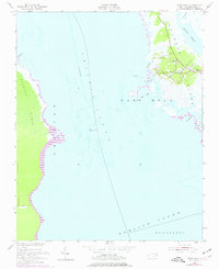
1953 Map of Wanchese
USGS Topo · Published 1977About this map
Roanoke Island is the centerpiece of this mid-century maritime study, focused on the southern tip where the village of Wanchese meets the convergence of the Croatan Sound and Pamlico Sound. The map reveals a community deeply integrated with the water, showing the intricate network of inlets and landings including Oyster Creek, Broad Creek, and the Cut Through. Local life is anchored at the intersection of Route 345, where Bethany Ch and a local Cem are situated near the small settlement of Baumtown.
Find a feature on this map
21 named features on this map. Tap any name to fly to it.
Don’t see what you’re looking for? This feature index may not catch every label — zoom into the map to look around manually.
Map Details
Editions of this 1953 Wanchese Map
5 editions found
Other maps of this area

1943 · Roanoke Island
USGS Topo · 1:125,000

1953 · Wanchese
USGS Topo · 1:24,000

1953 · Roanoke Island NE
USGS Topo · 1:24,000

1953 · Stumpy Point
USGS Topo · 1:24,000

1953 · Manteo
USGS Topo · 1:24,000

1953 · East Lake SE
USGS Topo · 1:24,000

1953 · Manns Harbor
USGS Topo · 1:24,000

1953 · Engelhard NE
USGS Topo · 1:24,000

1955 · Wanchese
USGS Topo · 1:250,000

1957 · Manteo
USGS Topo · 1:250,000