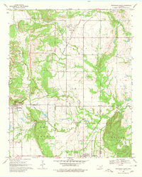
1969 Map of Wapanucka North
USGS Topo · Published 1980About this map
Clarita and Bromide serve as the primary hubs in this late 1960s landscape, where the Kansas Oklahoma and Gulf Railroad dictates the movement of people and materials. The map reveals a complex intersection of administrative and ancestral lines, most notably the Old Indian Treaty Boundary running north-south through the center of the sheet. This boundary separates the western Ash Flat region from eastern territories, providing a spatial record of Oklahoma's transition from tribal lands to statehood.
Find a feature on this map
36 named features on this map. Tap any name to fly to it.
Don’t see what you’re looking for? This feature index may not catch every label — zoom into the map to look around manually.
Map Details
Editions of this 1969 Wapanucka North Map
2 editions found
Other maps of this area

1896 · Coalgate
USGS Topo · 1:125,000

1899 · Coalgate
USGS Topo · 1:125,000

1899 · Atoka
USGS Topo · 1:125,000

1900 · Atoka
USGS Topo · 1:125,000

1900 · Coalgate
USGS Topo · 1:125,000

1901 · Stonewall
USGS Topo · 1:125,000

1901 · Tishomingo
USGS Topo · 1:125,000

1957 · Centrahoma
USGS Topo · 1:24,000

1957 · Ardmore
USGS Topo · 1:250,000

1963 · Ardmore
USGS Topo · 1:250,000