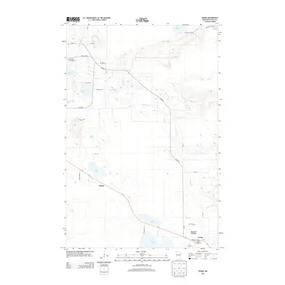
2013 Map of Warba
USGS Topo · Published 2013About this map
Warba serves as the primary hub in this portion of Itasca County, situated at the junction of Us-2 and the Swan River. The landscape is dominated by a complex network of glacial lakes and wetlands, including Sand Lake, Shallow Lake, and Rice Lake, which define the local topography and road patterns. Local history and genealogy are anchored by several distinct burial sites spread across the township, such as the Norwegian Cem, Trout Lake Cem, and Feeley Cem.
Find a feature on this map
41 named features on this map. Tap any name to fly to it.
Don’t see what you’re looking for? This feature index may not catch every label — zoom into the map to look around manually.
Map Details
Editions of this 2013 Warba Map
This is the sole edition of this map. No revisions or reprints were ever made.
Other maps of this area

1920 · Trout Lake
USGS Topo · 1:62,500

1952 · Calumet
USGS Topo · 1:24,000

1952 · Pengilly
USGS Topo · 1:24,000

1952 · Bovey
USGS Topo · 1:24,000

1954 · Hibbing
USGS Topo · 1:250,000

1957 · Hibbing
USGS Topo · 1:250,000

1958 · Hibbing
USGS Topo · 1:250,000

1964 · Hibbing
USGS Topo · 1:250,000

1969 · La Prairie
USGS Topo · 1:24,000
1969 · Goodland
USGS Topo · 1:24,000