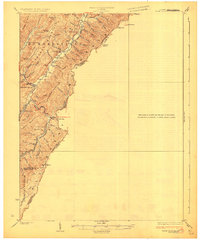
1926 Map of Warm Springs
USGS Topo · Published 1926About this map
Alleghany Mountains peaks and hollows define the border between West Virginia and Virginia in this mid-1920s survey. The landscape is dominated by long ridges like Brown Mountain and Dog Ridge Mountain, while the drainage patterns of Knapp Creek and Anthony Creek dictate the placement of human settlement. The map reveals a high density of rural infrastructure, particularly small schools such as Mt Tabor School, Sunset School, and Browne Creek School, which served isolated hollows before school consolidation. The presence of Westminster Church and the settlement at Minnehaha Springs mark the social centers of the Huntersville district. A network of secondary routes follows the natural contours of the valley floors, connecting family-named landmarks like Browne Ridge and Grindstone Knob through natural passes such as Rider Gap.
Find a feature on this map
49 named features on this map. Tap any name to fly to it.
Don’t see what you’re looking for? This feature index may not catch every label — zoom into the map to look around manually.
Map Details
Editions of this 1926 Warm Springs Map
5 editions found

Other maps of this area

1887 · Lewisburg
USGS Topo · 1:125,000

1891 · Lewisburg
USGS Topo · 1:125,000

1891 · Huntersville
USGS Topo · 1:125,000

1894 · Huntersville
USGS Topo · 1:125,000

1894 · Natural Bridge
USGS Topo · 1:125,000

1901 · Monterey
USGS Topo · 1:125,000

1921 · Callaghan
USGS Topo · 1:48,000

1922 · Cass
USGS Topo · 1:48,000

1923 · Marlinton
USGS Topo · 1:48,000

1923 · Warm Springs
USGS Topo · 1:48,000