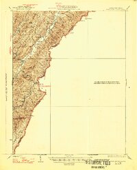
1926 Map of Warm Springs
USGS Topo · Published 1946About this map
Minnehaha Springs sits near the base of the Allegheny front, where the state boundary separates Pocahontas Co and Greenbrier Co, West Virginia, from Bath Co, Virginia. The landscape is defined by parallel ridges such as Brown Mountain and Miller Ridge, with life centered around the hollows and mountain gaps. The 1920s survey documents a network of rural education and faith, featuring numerous local institutions like Mt Tabor School, Sunset School, and Westminster Church. Waterways including Knapps Creek and Anthony Creek carve through the terrain, connecting small settlements and family-named landmarks like Shumate Hollow and Moore Hollow. The placement of Ryder Gap and high points like Mad Sheep highlights the difficult geography that shaped transportation and settlement patterns in this border region.
Find a feature on this map
35 named features on this map. Tap any name to fly to it.
Don’t see what you’re looking for? This feature index may not catch every label — zoom into the map to look around manually.
Map Details
Editions of this 1926 Warm Springs Map
5 editions found

Other maps of this area

1887 · Lewisburg
USGS Topo · 1:125,000

1891 · Lewisburg
USGS Topo · 1:125,000

1891 · Huntersville
USGS Topo · 1:125,000

1894 · Huntersville
USGS Topo · 1:125,000

1894 · Natural Bridge
USGS Topo · 1:125,000

1901 · Monterey
USGS Topo · 1:125,000

1921 · Callaghan
USGS Topo · 1:48,000

1922 · Cass
USGS Topo · 1:48,000

1923 · Marlinton
USGS Topo · 1:48,000

1923 · Warm Springs
USGS Topo · 1:48,000