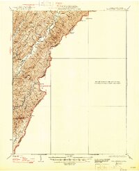
1926 Map of Warm Springs
USGS Topo · Published 1946About this map
Minnehaha Springs serves as a central landmark in this 1920s topography, situated where the terrain transitions across the West Virginia-Virginia border. The map highlights a localized network of rural education, identifying numerous institutions such as the Mt Tabor School, Moore School, and the Clyde Mrs School. These small schoolhouses, often named for nearby watercourses like Browns Creek School and Douthat Creek School, indicate the dispersed nature of mountain settlements during this era.
Find a feature on this map
34 named features on this map. Tap any name to fly to it.
Don’t see what you’re looking for? This feature index may not catch every label — zoom into the map to look around manually.
Map Details
Editions of this 1926 Warm Springs Map
5 editions found

Other maps of this area

1887 · Lewisburg
USGS Topo · 1:125,000

1891 · Lewisburg
USGS Topo · 1:125,000

1891 · Huntersville
USGS Topo · 1:125,000

1894 · Huntersville
USGS Topo · 1:125,000

1894 · Natural Bridge
USGS Topo · 1:125,000

1901 · Monterey
USGS Topo · 1:125,000

1921 · Callaghan
USGS Topo · 1:48,000

1922 · Cass
USGS Topo · 1:48,000

1923 · Marlinton
USGS Topo · 1:48,000

1923 · Warm Springs
USGS Topo · 1:48,000