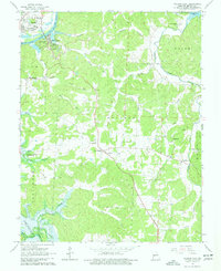
1964 Map of Warsaw East
USGS Topo · Published 1977About this map
The Osage River corridor near Warsaw underwent a significant transformation in the mid-1960s, as shown by the blue hatching marking future inundation for the Harry S Truman Reservoir. This era captures the landscape just before the rising waters altered the topography, with established rural communities like Majorville, Dell, and Old Fredonia still centered around traditional country landmarks. Numerous family and community burial grounds, including Pate Cem, White Cem, and Smith Cem, are plotted alongside local centers of worship such as Evening Shade Ch and the Turkey Creek Chapel.
Find a feature on this map
55 named features on this map. Tap any name to fly to it.
Don’t see what you’re looking for? This feature index may not catch every label — zoom into the map to look around manually.
Map Details
Editions of this 1964 Warsaw East Map
3 editions found
Other maps of this area

1887 · Warsaw
USGS Topo · 1:125,000

1894 · Warsaw
USGS Topo · 1:125,000

1935 · Edwards
USGS Topo · 1:24,000

1935 · Dell
USGS Topo · 1:24,000

1936 · Shawnee Bend
USGS Topo · 1:24,000

1936 · Lakeview Heights
USGS Topo · 1:24,000

1936 · Schuyler
USGS Topo · 1:24,000

1945 · Fristoe
USGS Topo · 1:62,500

1947 · Jefferson City
USGS Topo · 1:250,000

1954 · Jefferson City
USGS Topo · 1:250,000