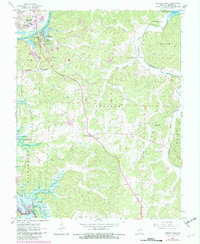
1964 Map of Warsaw East
USGS Topo · Published 1982About this map
The Osage River corridor and the town of Warsaw anchor this survey, which documents a landscape on the verge of significant hydrological change. Purple revisions from the late 1970s identify areas slated for inundation by the Harry S Truman Reservoir, contrasting with the established reaches of the Lake of the Ozarks to the east. Rural life is well-represented through numerous family-named landmarks and community centers such as Whitakerville, Majorville, and Dell.
Find a feature on this map
65 named features on this map. Tap any name to fly to it.
Don’t see what you’re looking for? This feature index may not catch every label — zoom into the map to look around manually.
Map Details
Editions of this 1964 Warsaw East Map
3 editions found
Other maps of this area

1887 · Warsaw
USGS Topo · 1:125,000

1894 · Warsaw
USGS Topo · 1:125,000

1935 · Edwards
USGS Topo · 1:24,000

1935 · Dell
USGS Topo · 1:24,000

1936 · Shawnee Bend
USGS Topo · 1:24,000

1936 · Lakeview Heights
USGS Topo · 1:24,000

1936 · Schuyler
USGS Topo · 1:24,000

1945 · Fristoe
USGS Topo · 1:62,500

1947 · Jefferson City
USGS Topo · 1:250,000

1954 · Jefferson City
USGS Topo · 1:250,000