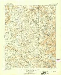
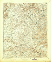
1896 Map of Wartburg
USGS Topo · Published 1950About this map
Cincinnati Southern RR tracks bisect this rugged section of the Cumberland Plateau, serving as a vital industrial artery for mountain settlements like Sunbright and Glenmary. Established during a period of planned colonization and industrial expansion, the map highlights unique communities such as the English utopian colony of Rugby near the Emory River. The landscape is defined by deep incisions from the Obed River and Clear Creek, creating dramatic terrain features like The Temple and Pilot Mountain. Numerous family-named hollows and coves, including Carpenter Hollow and Gwin Cove, indicate a pattern of scattered homesteading and early timber extraction. Major county seats and centers of trade like Wartburg and Jamestown anchor the region, while smaller vanished points like Genesis and Armathwaite reflect the early social geography of Fentress, Scott, and Morgan counties.
Find a feature on this map
177 named features on this map. Tap any name to fly to it.
Don’t see what you’re looking for? This feature index may not catch every label — zoom into the map to look around manually.
Map Details
Editions of this 1896 Wartburg Map
6 editions found

Other maps of this area

1887 · Kingston
USGS Topo · 1:125,000

1890 · Williamsburg
USGS Topo · 1:125,000

1891 · Kingston
USGS Topo · 1:125,000

1892 · Pikeville
USGS Topo · 1:125,000

1893 · Briceville
USGS Topo · 1:125,000

1893 · Kingston
USGS Topo · 1:125,000

1894 · Williamsburg
USGS Topo · 1:125,000

1895 · Wartburg
USGS Topo · 1:125,000

1895 · Loudon
USGS Topo · 1:125,000

1895 · Briceville
USGS Topo · 1:125,000