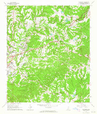
1963 Map of Washington
USGS Topo · Published 1964About this map
The historic campus of Jefferson Military College stands as a focal point near Washington, reflecting the early educational and civic life of Adams County. To the west, the residential growth of Morgantown and the eastern fringes of Natchez are clearly delineated, showing a transition from dense settlement to the winding corridors of St Catherine Creek. The landscape is a network of ridges and bayous, where numerous cemeteries like Foster Mound Cem and Sweet Auburn Cem suggest long-established family homesteads and church congregations.
Find a feature on this map
62 named features on this map. Tap any name to fly to it.
Don’t see what you’re looking for? This feature index may not catch every label — zoom into the map to look around manually.
Map Details
Editions of this 1963 Washington Map
2 editions found
Other maps of this area

1909 · Vidalia
USGS Topo · 1:24,000

1921 · Natchez
USGS Topo · 1:48,000

1922 · Natchez
USGS Topo · 1:62,500

1939 · Natchez
USGS Topo · 1:62,500

1939 · Kingston
USGS Topo · 1:62,500

1953 · Natchez
USGS Topo · 1:250,000

1956 · Natchez
USGS Topo · 1:250,000

1958 · Kingston
USGS Topo · 1:62,500

1959 · Natchez
USGS Topo · 1:250,000

1961 · Crosby
USGS Topo · 1:62,500