
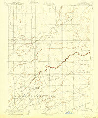
1908 Map of Waterloo
USGS Topo · Published 1908About this map
The Campo De Los Franceses land grant dominates the southern portion of this 1907 survey, revealing the enduring footprint of Mexican-era ranchos on the California landscape. The settlement of Waterloo serves as a central hub, situated near the confluence of local transit routes and the winding Calaveras River. The map highlights a burgeoning agricultural region connected by the Central California Traction railroad and a network of early thoroughfares including the Upper Sacramento Road and Waterloo Road. Scattered educational landmarks like the Greenwood School and another unnamed School near Bear Creek reflect the rural community's development. This survey, conducted under State Engineer Nathaniel Ellery, captures the transition from large pastoral tracts to a more structured grid of townships and sections.
Find a feature on this map
11 named features on this map. Tap any name to fly to it.
Don’t see what you’re looking for? This feature index may not catch every label — zoom into the map to look around manually.
Map Details
Editions of this 1908 Waterloo Map
2 editions found
Other maps of this area

1894 · Lodi
USGS Topo · 1:125,000

1908 · Linden
USGS Topo · 1:31,680

1908 · Lockeford
USGS Topo · 1:31,680

1909 · Clements
USGS Topo · 1:31,680

1910 · Castle
USGS Topo · 1:31,680

1910 · Woodbridge
USGS Topo · 1:31,680

1913 · Stockton
USGS Topo · 1:31,680

1914 · Burnham
USGS Topo · 1:31,680

1915 · Peters
USGS Topo · 1:31,680
1939 · Lodi
USGS Topo · 1:62,500