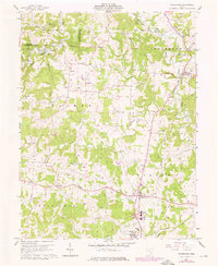
1960 Map of Watertown
USGS Topo · Published 1976About this map
Wolf Creek and its many forks define the landscape of western Washington County, where agricultural patterns meet the growing footprint of energy extraction. This survey, updated with 1975 revisions, documents a network of rural communities including Watertown, Barlow, and Vincent as they appeared in the mid-20th century. Local landmarks like Camp Hervida and Oak Hill Ch reflect the social foundations of the area, while the presence of numerous Oil Well and Gas Well sites indicates the industrial character of the hills. Of particular interest to local historians is the Old Railroad Grade winding through the south, marking a transportation corridor that once linked these hilltop settlements. The map also records the transition from smaller rural schools to consolidated facilities like the Barlow-Vincent Sch and Warren High Sch, alongside numerous family cemeteries such as Stanley Cem and the Murdock Cem.
Find a feature on this map
37 named features on this map. Tap any name to fly to it.
Don’t see what you’re looking for? This feature index may not catch every label — zoom into the map to look around manually.
Map Details
Editions of this 1960 Watertown Map
3 editions found

Other maps of this area

1902 · Parkersburg
USGS Topo · 1:62,500

1904 · Parkersburg
USGS Topo · 1:62,500

1904 · Chesterhill
USGS Topo · 1:62,500

1906 · Chesterhill
USGS Topo · 1:62,500

1909 · Caldwell
USGS Topo · 1:62,500

1910 · Mc Connelsville
USGS Topo · 1:62,500

1912 · Caldwell
USGS Topo · 1:62,500

1949 · Clarksburg
USGS Topo · 1:250,000

1956 · Clarksburg
USGS Topo · 1:250,000
1957 · Parkersburg
USGS Topo · 1:24,000