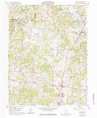
1960 Map of Watertown
USGS Topo · Published 1984About this map
The drainage of Wolf Creek and its many branches defines the settlement patterns of western Washington County during the mid-20th century. This terrain is characterized by a dense network of resource extraction, with numerous Oil Wells and Gas Wells scattered across the uplands of Windsor and Palmer townships. The local economy and social structure are evidenced by rural landmarks such as Camp Hervida and a series of country churches including Palmer Ch and Oak Hill Ch. The community of Barlow serves as a central hub, where the Barlow-Vincent Sch and Warren High Sch reflect the consolidation of educational facilities in the region. Transportation history is noted in the southern portion of the map, where an Old Railroad Grade follows the path of Tupper Creek near Vincent, marking a transition from rail to the burgeoning road network shown in the 1975 revisions.
Find a feature on this map
39 named features on this map. Tap any name to fly to it.
Don’t see what you’re looking for? This feature index may not catch every label — zoom into the map to look around manually.
Map Details
Editions of this 1960 Watertown Map
3 editions found

Other maps of this area

1902 · Parkersburg
USGS Topo · 1:62,500

1904 · Parkersburg
USGS Topo · 1:62,500

1904 · Chesterhill
USGS Topo · 1:62,500

1906 · Chesterhill
USGS Topo · 1:62,500

1909 · Caldwell
USGS Topo · 1:62,500

1910 · Mc Connelsville
USGS Topo · 1:62,500

1912 · Caldwell
USGS Topo · 1:62,500

1949 · Clarksburg
USGS Topo · 1:250,000

1956 · Clarksburg
USGS Topo · 1:250,000
1957 · Parkersburg
USGS Topo · 1:24,000