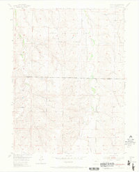
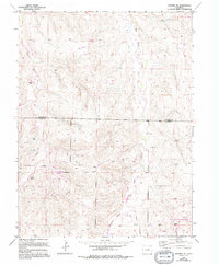
1955 Map of Watkins SE
USGS Topo · Published 1968About this map
Lowry Air Force Base Bombing Range dominates the northern half of this mid-century landscape, illustrating the significant military footprint in the region following World War II. The terrain is defined by the drainage patterns of Coal Creek and Box Elder Creek, which carve through the plains. Traces of early 20th-century rural life remain visible at Schley Sch, a remote schoolhouse serving the scattered ranching community. The map clearly delineates the Military Reservation Boundary as it intersects the Arapahoe Co Elbert Co line, showing the convergence of civil and federal jurisdictions. In the southern reaches, the topography becomes more pronounced near Hay Gulch, where numerous windmills indicate the ongoing reliance on groundwater for livestock and homesteading.
Find a feature on this map
7 named features on this map. Tap any name to fly to it.
Don’t see what you’re looking for? This feature index may not catch every label — zoom into the map to look around manually.
Map Details
Editions of this 1955 Watkins SE Map
6 editions found

Other maps of this area

1890 · East Denver
USGS Topo · 1:125,000

1894 · Castle Rock
USGS Topo · 1:125,000

1913 · Castle Rock
USGS Topo · 1:125,000

1939 · Coal Creek
USGS Topo · 1:24,000

1939 · Elizabeth
USGS Topo · 1:62,500

1940 · Piney Creek
USGS Topo · 1:24,000

1942 · Piney Creek
USGS Topo · 1:31,680

1942 · Coal Creek
USGS Topo · 1:31,680

1945 · Elizabeth
USGS Topo · 1:62,500

1953 · Denver
USGS Topo · 1:250,000