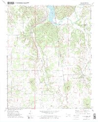
1972 Map of Watts
USGS Topo · Published 1974About this map
Watts and Westville serve as primary anchors in this borderland landscape, where the Oklahoma Arkansas state line and the Old Indian Treaty Boundary trace historical jurisdictional limits. The Kansas City Southern railroad cuts a diagonal path through the terrain, passing through Ballard and paralleling Ballard Creek. While much of the land is defined by the Illinois River and Lake Frances, the area is densely populated with sites for genealogical research, including the Sixkiller Cem, Brady West Cem, and Old Union Cem. Notable local landmarks like the Nicodemus Community Ctr and several small chapels such as Faith Chapel and Ballard Ch indicate the dispersed nature of these rural communities in the early 1970s. Prominent summits like Mission Mountain and Bates Mountain rise above the drainage basins of Cincinnati Creek and Peacheater Creek.
Find a feature on this map
38 named features on this map. Tap any name to fly to it.
Don’t see what you’re looking for? This feature index may not catch every label — zoom into the map to look around manually.
Map Details
Editions of this 1972 Watts Map
2 editions found
Other maps of this area

1898 · Tahlequah
USGS Topo · 1:125,000

1898 · Winslow
USGS Topo · 1:125,000

1899 · Fayetteville
USGS Topo · 1:125,000

1899 · Siloam Springs
USGS Topo · 1:125,000

1901 · Winslow
USGS Topo · 1:125,000

1901 · Fayetteville
USGS Topo · 1:125,000

1901 · Tahlequah
USGS Topo · 1:125,000

1903 · Siloam Springs
USGS Topo · 1:125,000

1904 · Siloam Springs
USGS Topo · 1:125,000

1904 · Fayetteville
USGS Topo · 1:125,000