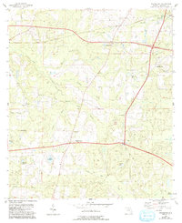
1955 Map of Waukeenah
USGS Topo · Published 1993About this map
Waukeenah serves as a central hub in this north Florida landscape, where a network of rural roads connects scattered agricultural communities during the mid-20th century. The area is defined by its numerous small-scale water systems, including Bailey Mill Creek and Cooksey Branch, which drain into several named basins like Lake Catherine and Shadow Lake. The social fabric of the era is clearly visible through the density of community landmarks, such as St Rilla Sch and Pine Grove Ch. A distinctive Base Line bisects the terrain, marking a critical reference for surveyors and property boundaries. Further north, the settlement of Drifton and the nearby Drifton Branch sit along the primary rail line, illustrating the importance of transport links to these inland Florida settlements. Researchers will find a high concentration of country churches, including Sardis Ch, Ebenezer Ch, and Bethel Ch, each serving as a historical anchor for local families and genealogy.
Find a feature on this map
30 named features on this map. Tap any name to fly to it.
Don’t see what you’re looking for? This feature index may not catch every label — zoom into the map to look around manually.
Map Details
Editions of this 1955 Waukeenah Map
3 editions found
Other maps of this area

1954 · Lloyd
USGS Topo · 1:24,000

1954 · Cody
USGS Topo · 1:24,000

1954 · Valdosta
USGS Topo · 1:250,000

1954 · Tallahassee
USGS Topo · 1:250,000

1955 · Lamont
USGS Topo · 1:24,000

1955 · Waukeenah
USGS Topo · 1:24,000

1955 · Lamont SE
USGS Topo · 1:24,000

1955 · Wacissa
USGS Topo · 1:24,000

1958 · Valdosta
USGS Topo · 1:250,000

1959 · Tallahassee
USGS Topo · 1:250,000