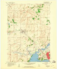
1959 Map of Waunakee
USGS Topo · Published 1960About this map
The village of Waunakee sits at the heart of this late-1950s survey, surrounded by the fertile glacial plains of northern Dane County. The landscape is defined by the headwaters of Sixmile Creek and the marshy expanses leading toward the northern shores of Lake Mendota. Evidence of the region’s mid-century institutional growth is clear at the southern edge of the map, where the sprawling grounds of Mendota State Hospital and the Central Wisconsin Training School occupy the shoreline near Farwells Point. Local education and community life are well-documented through scattered rural landmarks like the Catfish Sch and Norway Grove Sch, alongside three distinct burial grounds including Vienna Cem. The Chicago and Northwestern railroad corridor provides a primary axis for the settlements of Dane and Waunakee, mirroring the transition from agricultural land to the expanding suburban reach of Madison.
Find a feature on this map
35 named features on this map. Tap any name to fly to it.
Don’t see what you’re looking for? This feature index may not catch every label — zoom into the map to look around manually.
Map Details
Editions of this 1959 Waunakee Map
3 editions found
Other maps of this area

1890 · Madison
USGS Topo · 1:62,500

1892 · Madison
USGS Topo · 1:62,500

1895 · Baraboo
USGS Topo · 1:62,500

1901 · Poynette
USGS Topo · 1:62,500

1904 · Madison
USGS Topo · 1:62,500

1906 · Madison
USGS Topo · 1:62,500

1907 · Cross Plains
USGS Topo · 1:62,500

1908 · Baraboo
USGS Topo · 1:62,500

1909 · Cross Plains
USGS Topo · 1:62,500

1957 · Madison
USGS Topo · 1:250,000