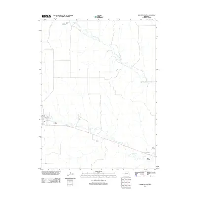
2011 Map of Wauneta East
USGS Topo · Published 2011About this map
Wauneta serves as the primary hub in this corner of Chase County, situated where the valley of Frenchman Creek meets the agricultural uplands. The settlement is anchored by the Wauneta Post Office and sits at the junction of several county roads, including 346 Ave and 728 RD. The landscape is defined by its drainage systems, with Stinking Water Creek carving a path through the northern half of the region. To the north, the Moody Reservoir and its associated Moody Dam indicate the local importance of water management in this prairie environment. The southern portion of the map reveals a more dissected terrain marked by prominent local features like Horse Canyon, Trail Canyon, and Sand Canyon. The presence of Old US Hwy 6 highlights a historic transportation corridor that has long connected these high plains communities.
Find a feature on this map
16 named features on this map. Tap any name to fly to it.
Don’t see what you’re looking for? This feature index may not catch every label — zoom into the map to look around manually.
Map Details
Editions of this 2011 Wauneta East Map
This is the sole edition of this map. No revisions or reprints were ever made.
Other maps of this area

1954 · McCook
USGS Topo · 1:250,000

1957 · McCook
USGS Topo · 1:250,000

1958 · McCook
USGS Topo · 1:250,000

1973 · Wauneta SW
USGS Topo · 1:24,000

1973 · Palisade SW
USGS Topo · 1:24,000

1973 · Wauneta SE
USGS Topo · 1:24,000

1974 · Hamlet
USGS Topo · 1:24,000

1974 · Dittons Creek SE
USGS Topo · 1:24,000
1974 · Wauneta West
USGS Topo · 1:24,000
1974 · Dittons Creek
USGS Topo · 1:24,000