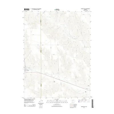
2014 Map of Wauneta East
USGS Topo · Published 2014About this map
Wauneta anchors the western edge of this landscape where Frenchman Cr carves a path through the plains of southwest Nebraska. The map illustrates a transitional terrain defined by significant drainage systems, including Stinking Water Cr to the north and a series of deep cuts such as Horse Canyon and Sand Canyon further south. These natural features dictated the early road patterns and land use in this section of the state, visible in the way Highway 6A and various rural routes navigate the undulating contours.
Find a feature on this map
19 named features on this map. Tap any name to fly to it.
Don’t see what you’re looking for? This feature index may not catch every label — zoom into the map to look around manually.
Map Details
Editions of this 2014 Wauneta East Map
This is the sole edition of this map. No revisions or reprints were ever made.
Other maps of this area

1954 · McCook
USGS Topo · 1:250,000

1957 · McCook
USGS Topo · 1:250,000

1958 · McCook
USGS Topo · 1:250,000

1973 · Wauneta SW
USGS Topo · 1:24,000

1973 · Palisade SW
USGS Topo · 1:24,000

1973 · Wauneta SE
USGS Topo · 1:24,000

1974 · Hamlet
USGS Topo · 1:24,000

1974 · Dittons Creek SE
USGS Topo · 1:24,000
1974 · Wauneta West
USGS Topo · 1:24,000
1974 · Dittons Creek
USGS Topo · 1:24,000