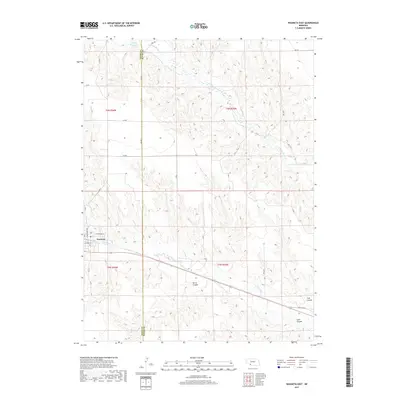
2017 Map of Wauneta East
USGS Topo · Published 2017About this map
Wauneta anchors the western edge of this High Plains landscape, situated at the confluence where Frenchman Cr meets the local drainage systems. The terrain is defined by a network of deeply incised draws and canyons, including Horse Canyon, Trail Canyon, and Sand Canyon, which carve through the agricultural tablelands of Chase and Hayes counties. Water management is central to the area's geography, evidenced by Moody Reservoir in the north and the winding path of Stinking Water Cr. The infrastructure reflects a traditional grid of section-line roads, with Old US Hwy 6 providing the primary east-west corridor through the valley. This 2017 survey illustrates the persistent importance of water resources and topography in shaping the settlement patterns and road networks of Southwest Nebraska.
Find a feature on this map
31 named features on this map. Tap any name to fly to it.
Don’t see what you’re looking for? This feature index may not catch every label — zoom into the map to look around manually.
Map Details
Editions of this 2017 Wauneta East Map
This is the sole edition of this map. No revisions or reprints were ever made.
Other maps of this area

1954 · McCook
USGS Topo · 1:250,000

1957 · McCook
USGS Topo · 1:250,000

1958 · McCook
USGS Topo · 1:250,000

1973 · Wauneta SW
USGS Topo · 1:24,000

1973 · Palisade SW
USGS Topo · 1:24,000

1973 · Wauneta SE
USGS Topo · 1:24,000

1974 · Hamlet
USGS Topo · 1:24,000

1974 · Dittons Creek SE
USGS Topo · 1:24,000
1974 · Wauneta West
USGS Topo · 1:24,000
1974 · Dittons Creek
USGS Topo · 1:24,000