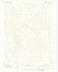
1971 Map of Wauneta
USGS Topo · Published 1974About this map
Wauneta serves as the primary focal point in this 1971 topographical study of eastern Yuma County, positioned at a vital crossroads in an agricultural landscape. The terrain is characterized by a dense distribution of groundwater resources, with numerous Well sites marked across the grid-patterned sections, signifying the importance of subsurface irrigation to the local economy. This survey, conducted just after the 1970 aerial photography by the U.S. Geological Survey, illustrates the rural development patterns of the Colorado plains, where fine red dashed lines delineate specific fence lines and property boundaries. The map provides a precise look at the township and range system, specifically noting the intersection of T. 5 N. / T. 4 N. and R. 45 W. / R. 44 W., which dictated the settlement and land use of this high plains region.
Find a feature on this map
5 named features on this map. Tap any name to fly to it.
Don’t see what you’re looking for? This feature index may not catch every label — zoom into the map to look around manually.
Map Details
Editions of this 1971 Wauneta Map
3 editions found
Other maps of this area

1954 · Sterling
USGS Topo · 1:250,000

1958 · Sterling
USGS Topo · 1:250,000

1971 · Alvin NW
USGS Topo · 1:24,000

1971 · Alvin SW
USGS Topo · 1:24,000

1971 · Fiddler Peak
USGS Topo · 1:24,000

1971 · Wauneta NE
USGS Topo · 1:24,000

1971 · Wauneta
USGS Topo · 1:24,000

1971 · Eckley NE
USGS Topo · 1:24,000
1971 · Wray NW
USGS Topo · 1:24,000

1971 · Old Baldy
USGS Topo · 1:24,000