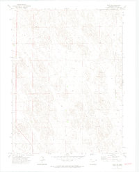
1971 Map of Wray NW
USGS Topo · Published 1974About this map
High plains terrain in Yuma County defines this landscape, mapped during a 1971 field check. The area is characterized by sparse development and a reliance on groundwater, evidenced by numerous Well sites distributed across the township grids of T. 3 N. and T. 2 N.. The most prominent named landmark is Bushong, situated in the eastern portion of the quadrangle. Industrial and utility infrastructure is minimal but specific, featuring a Substa and a Gravel Pit located in the southwestern and southeastern sections. This survey provides a precise look at the rural infrastructure of eastern Colorado before the further intensification of center-pivot irrigation and modern agricultural shifts in the late 20th century.
Find a feature on this map
5 named features on this map. Tap any name to fly to it.
Don’t see what you’re looking for? This feature index may not catch every label — zoom into the map to look around manually.
Map Details
Editions of this 1971 Wray NW Map
3 editions found
Other maps of this area

1954 · Sterling
USGS Topo · 1:250,000

1958 · Sterling
USGS Topo · 1:250,000

1961 · Robb
USGS Topo · 1:24,000

1961 · Laird
USGS Topo · 1:24,000

1961 · Wray
USGS Topo · 1:24,000

1971 · Alvin SW
USGS Topo · 1:24,000

1971 · Alvin
USGS Topo · 1:24,000

1971 · Wauneta
USGS Topo · 1:24,000

1971 · Wray NE
USGS Topo · 1:24,000

1971 · Eckley NE
USGS Topo · 1:24,000