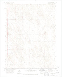
1971 Map of Wray NW
USGS Topo · Published 1974About this map
The High Plains of Yuma County appear as a landscape of subtle relief and specialized infrastructure in this early 1970s topographic study. The terrain is sparsely settled, defined by the grid of section lines and the essential water management of the region. Distinctive local markers include the Bushong location and a Substa, which highlight the rural utility network of this agricultural area. While few permanent settlements are named, the map documents the extraction of local resources at a Gravel Pit and several unnamed wells, reflecting the industrial character of the eastern Colorado plains. This 1:24,000 scale survey provides a precise look at the land before further modern consolidation, capturing the township boundaries of T. 3 N. and T. 2 N. during a period of steady ranching and resource use.
Find a feature on this map
5 named features on this map. Tap any name to fly to it.
Don’t see what you’re looking for? This feature index may not catch every label — zoom into the map to look around manually.
Map Details
Editions of this 1971 Wray NW Map
3 editions found
Other maps of this area

1954 · Sterling
USGS Topo · 1:250,000

1958 · Sterling
USGS Topo · 1:250,000

1961 · Robb
USGS Topo · 1:24,000

1961 · Laird
USGS Topo · 1:24,000

1961 · Wray
USGS Topo · 1:24,000

1971 · Alvin SW
USGS Topo · 1:24,000

1971 · Alvin
USGS Topo · 1:24,000

1971 · Wauneta
USGS Topo · 1:24,000

1971 · Wray NE
USGS Topo · 1:24,000

1971 · Eckley NE
USGS Topo · 1:24,000