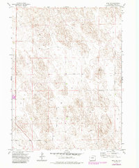
1971 Map of Wray NW
USGS Topo · Published 1985About this map
The High Plains of Yuma County are defined by a complex network of geological depressions and water management in this 1971 study, revised through 1984. The landscape is marked by numerous Wells, reflecting the essential nature of groundwater for agricultural and residential sustainability in this part of eastern Colorado. Near the center of the sheet, the named terrain of Bushong stands out amidst the contours, while the southern edge is anchored by the corridor of Highway 385. Infrastructure and industrial use are visible through features like the Substa and a Gravel Pit located near the western boundary. Precision markers, including Bm 3712 and Bm 3691, provide a record of early 1970s surveying benchmarks for the region.
Find a feature on this map
9 named features on this map. Tap any name to fly to it.
Don’t see what you’re looking for? This feature index may not catch every label — zoom into the map to look around manually.
Map Details
Editions of this 1971 Wray NW Map
3 editions found
Other maps of this area

1954 · Sterling
USGS Topo · 1:250,000

1958 · Sterling
USGS Topo · 1:250,000

1961 · Robb
USGS Topo · 1:24,000

1961 · Laird
USGS Topo · 1:24,000

1961 · Wray
USGS Topo · 1:24,000

1971 · Alvin SW
USGS Topo · 1:24,000

1971 · Alvin
USGS Topo · 1:24,000

1971 · Wauneta
USGS Topo · 1:24,000

1971 · Wray NE
USGS Topo · 1:24,000

1971 · Eckley NE
USGS Topo · 1:24,000