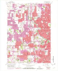
1958 Map of Wauwatosa
USGS Topo · Published 1982About this map
The Menomonee River and Honey Creek valley define the western suburban expansion of Milwaukee in the late 1950s, a period marked by the conversion of agricultural land into dense residential neighborhoods and institutional complexes. This survey shows the extensive footprint of the Milwaukee County Institutions and several prominent religious and educational centers, including the Notre Dame Convent and Mount Mary College. The transition from rural to suburban is evident as established towns like Butler and Elm Grove are linked by expanding transportation corridors such as Watertown Plank Rd and the Chicago and North Western railway. Large-scale cemetery developments like Wisconsin Memorial Park Cemetery and Valhalla Cemetery occupy significant acreage, while Timmerman Airport serves as a regional aviation hub amidst the growing sprawl.
Find a feature on this map
90 named features on this map. Tap any name to fly to it.
Don’t see what you’re looking for? This feature index may not catch every label — zoom into the map to look around manually.
Map Details
Editions of this 1958 Wauwatosa Map
4 editions found
Other maps of this area

1891 · Bayview
USGS Topo · 1:62,500

1891 · Muskego
USGS Topo · 1:62,500

1892 · Milwaukee
USGS Topo · 1:62,500

1892 · Waukesha
USGS Topo · 1:62,500

1901 · Milwaukee
USGS Topo · 1:62,500

1901 · Waukesha
USGS Topo · 1:62,500

1901 · Bayview
USGS Topo · 1:62,500

1901 · Muskego
USGS Topo · 1:62,500

1906 · Waukesha
USGS Topo · 1:62,500

1906 · Milwaukee
USGS Topo · 1:62,500