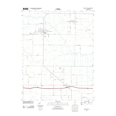
2012 Map of Wayne City
USGS Topo · Published 2012About this map
Wayne City serves as the primary hub of this Southern Illinois landscape, where the agricultural grid meets the winding course of the Skillet Fork river. The area is characterized by a dense network of country roads, including W Section Line Rd and Shaeffer Rd, which connect small outlying settlements such as Sims, Smithville, and Mayberry. The survey reveals a region deeply rooted in local heritage, as evidenced by several family and community burial grounds including Thomason Cem, Baltimore Cem, and Trotter Cem. To the east, the terrain rises toward Fleming Ridge, overlooking the complex hydrology of Fish Slough and the uniquely named Skillet Lagoon. The inclusion of the Skillet Fork Farm Airport reflects the continued integration of modern aviation within this traditional farming community.
Find a feature on this map
61 named features on this map. Tap any name to fly to it.
Don’t see what you’re looking for? This feature index may not catch every label — zoom into the map to look around manually.
Map Details
Editions of this 2012 Wayne City Map
This is the sole edition of this map. No revisions or reprints were ever made.
Other maps of this area

1941 · Enfield
USGS Topo · 1:62,500

1942 · McLeansboro
USGS Topo · 1:62,500

1944 · Enfield
USGS Topo · 1:62,500

1945 · McLeansboro
USGS Topo · 1:62,500

1947 · Wayne City
USGS Topo · 1:62,500

1948 · Fairfield
USGS Topo · 1:62,500

1958 · Belleville
USGS Topo · 1:250,000

1962 · Belleville
USGS Topo · 1:250,000
1970 · Geff
USGS Topo · 1:24,000
1971 · Boyleston
USGS Topo · 1:24,000