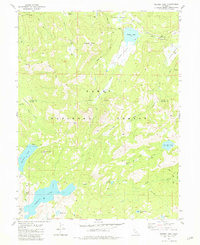
1981 Map of Webber Peak
USGS Topo · Published 1981About this map
Henness Pass Road traverses the northern high country of the Tahoe National Forest in this 1981 record of the Sierra Nevada. The terrain is defined by a dense network of water bodies and high-elevation meadows, including Webber Lake, Fordyce Lake, and the sprawling Perazzo Meadows along the Little Truckee River. The map highlights the intersection of early pioneer thoroughfares with modern recreation, as the Pacific Crest National Scenic Trail winds through the landscape past Meadow Lake Hill and Webber Peak.
Find a feature on this map
34 named features on this map. Tap any name to fly to it.
Don’t see what you’re looking for? This feature index may not catch every label — zoom into the map to look around manually.
Map Details
Editions of this 1981 Webber Peak Map
3 editions found
Other maps of this area

1890 · Sierraville
USGS Topo · 1:125,000

1891 · Downieville
USGS Topo · 1:125,000

1891 · Colfax
USGS Topo · 1:125,000

1891 · Truckee
USGS Topo · 1:125,000

1892 · Sierraville
USGS Topo · 1:125,000

1892 · Colfax
USGS Topo · 1:125,000

1893 · Truckee
USGS Topo · 1:125,000

1893 · Downieville
USGS Topo · 1:125,000

1894 · Colfax
USGS Topo · 1:125,000

1894 · Sierraville
USGS Topo · 1:125,000