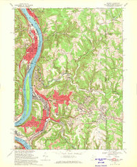
1968 Map of Weirton
USGS Topo · Published 1970About this map
The Ohio River forms the industrial backbone of this corridor, where the Penn Central railroad tracks parallel the water to serve the heavy manufacturing centers of Weirton and Toronto. The map reveals the intense mid-century development of the tri-state area, with the sprawling residential neighborhoods of Weirton Heights and Marland Heights expanding eastward into the hills. Notable for its industrial footprint, the sheet identifies the Slag Dump and Filtration Plant essential to the local economy. Beyond the steel-town core, the landscape transitions to the small-town character of New Cumberland and the rural hills of Butler and Clay townships. Local landmarks like the Williams Country Club and the Weirton Airport illustrate the city's mid-century peak, while sites like the Sacred Heart of Mary Ch and Union Cem offer essential data for genealogical research in this historic border region.
Find a feature on this map
62 named features on this map. Tap any name to fly to it.
Don’t see what you’re looking for? This feature index may not catch every label — zoom into the map to look around manually.
Map Details
Editions of this 1968 Weirton Map
3 editions found
Other maps of this area

1901 · Beaver
USGS Topo · 1:62,500

1904 · Wellsville
USGS Topo · 1:62,500

1904 · Steubenville
USGS Topo · 1:62,500

1904 · Beaver
USGS Topo · 1:62,500

1904 · Burgettstown
USGS Topo · 1:62,500

1906 · Burgettstown
USGS Topo · 1:62,500

1935 · Steubenville
USGS Topo · 1:62,500

1937 · Wellsville
USGS Topo · 1:62,500

1942 · Steubenville
USGS Topo · 1:62,500

1944 · Wellsville
USGS Topo · 1:62,500