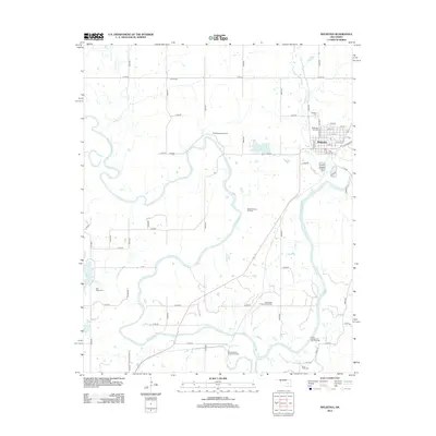
2012 Map of Weleetka
USGS Topo · Published 2012About this map
The town of Weleetka sits at a strategic bend of the N Canadian River in this 2012 study of the Oklahoma landscape. This region, defined by the winding river and its tributaries like Alabama Cr and Flat Rock Cr, shows a long-standing reliance on energy extraction. Numerous designated zones, including the West Weleetka Oil Field and the South Alabama Oil and Gas Field, demonstrate the intensive petroleum and natural gas operations that have shaped the local economy and land use patterns over decades.
Find a feature on this map
56 named features on this map. Tap any name to fly to it.
Don’t see what you’re looking for? This feature index may not catch every label — zoom into the map to look around manually.
Map Details
Editions of this 2012 Weleetka Map
This is the sole edition of this map. No revisions or reprints were ever made.
Other maps of this area

1900 · Wewoka
USGS Topo · 1:125,000

1954 · Oklahoma City
USGS Topo · 1:250,000

1957 · Oklahoma City
USGS Topo · 1:250,000

1963 · Oklahoma City
USGS Topo · 1:250,000
1967 · Pharoah
USGS Topo · 1:24,000

1967 · Okemah SE
USGS Topo · 1:24,000

1967 · Weleetka
USGS Topo · 1:24,000

1967 · Okemah
USGS Topo · 1:24,000
1967 · Clearview
USGS Topo · 1:24,000
1967 · Dustin
USGS Topo · 1:24,000