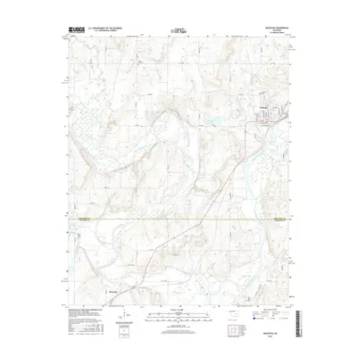
2016 Map of Weleetka
USGS Topo · Published 2016About this map
The North Canadian River carves a meandering path through the heart of the territory, serving as a natural boundary between Okfuskee and Hughes counties. The town of Weleetka sits on the northern side of this waterway, characterized by a structured street grid including Jack Johnson Dr and E Third St. To the southwest, the community of Wetumka is situated near the shores of Lake Wetumka, where the local landscape transitions into the riparian corridors of Flat Rock Cr. This survey documents a landscape defined by its proximity to water and a rural road network that connects several historic burial grounds. Genealogists will find interest in the locations of Fairlawn Cem and Crestwood Cem near the northern settlement, while Salt Creek Cem and Sand Creek Cem are located further south, often positioned near the smaller tributaries like Alabama Cr.
Find a feature on this map
52 named features on this map. Tap any name to fly to it.
Don’t see what you’re looking for? This feature index may not catch every label — zoom into the map to look around manually.
Map Details
Editions of this 2016 Weleetka Map
This is the sole edition of this map. No revisions or reprints were ever made.
Other maps of this area

1900 · Wewoka
USGS Topo · 1:125,000

1954 · Oklahoma City
USGS Topo · 1:250,000

1957 · Oklahoma City
USGS Topo · 1:250,000

1963 · Oklahoma City
USGS Topo · 1:250,000
1967 · Pharoah
USGS Topo · 1:24,000

1967 · Okemah SE
USGS Topo · 1:24,000

1967 · Weleetka
USGS Topo · 1:24,000

1967 · Okemah
USGS Topo · 1:24,000
1967 · Clearview
USGS Topo · 1:24,000
1967 · Dustin
USGS Topo · 1:24,000