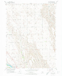
1956 Map of Wellfleet
USGS Topo · Published 1974About this map
Wellfleet serves as the primary hub in this Nebraska landscape, situated near the shores of Wellfleet Lake and the Chicago Burlington and Quincy railroad line. The map reveals a community structured around its civic and spiritual institutions, from the Community Center Sch and Echo Sch to the Lutheran Cem and Wellfleet Cem. The terrain is deeply inscribed by the hydrology of the High Plains, with dramatic drainage systems like Well Canyon and Hay Canyon carving through the surrounding plateaus. The presence of Medicine Lake and the Latimer landmark suggests a rural economy tied to water management and localized landholdings during the mid-1950s. The alignment of the railroad through the valley floor illustrates the historical reliance on rail for transporting goods and connecting these prairie settlements to larger markets.
Find a feature on this map
15 named features on this map. Tap any name to fly to it.
Don’t see what you’re looking for? This feature index may not catch every label — zoom into the map to look around manually.
Map Details
Editions of this 1956 Wellfleet Map
3 editions found
Other maps of this area

1954 · McCook
USGS Topo · 1:250,000

1956 · Wellfleet NW
USGS Topo · 1:24,000

1956 · White NE
USGS Topo · 1:24,000

1956 · Curtis NW
USGS Topo · 1:24,000

1956 · Curtis
USGS Topo · 1:24,000

1956 · Somerset
USGS Topo · 1:24,000

1956 · Wellfleet SE
USGS Topo · 1:24,000

1956 · Wellfleet
USGS Topo · 1:24,000

1956 · Wellfleet NE
USGS Topo · 1:24,000

1957 · McCook
USGS Topo · 1:250,000