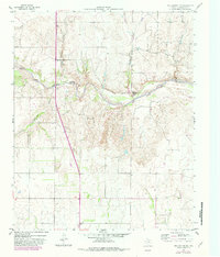
1959 Map of Wellington NW
USGS Topo · Published 1982About this map
The Salt Fork Red River carves a deep, winding path through this portion of Collingsworth County, defining the local geography with its intricate drainage system. Small settlements like Lutie and Branson appear along the upland routes, providing vital connection points for the surrounding ranching and agricultural land. A notable cultural landmark is the Pan Fork (Summer Camp), situated along the riverbank near the confluence with Panther Creek. The map documents a landscape transitioning from the late 1950s into the early 1980s, noting changes in woodland cover and road improvements. Economic activity is visible through features such as the Gravel Pit, while the natural hydrology is dominated by numerous seasonal draws including Indian Creek, Cottonwood Creek, and Willow Creek that feed into the primary river valley.
Find a feature on this map
10 named features on this map. Tap any name to fly to it.
Don’t see what you’re looking for? This feature index may not catch every label — zoom into the map to look around manually.
Map Details
Editions of this 1959 Wellington NW Map
2 editions found
Other maps of this area

1954 · Amarillo
USGS Topo · 1:250,000

1954 · Plainview
USGS Topo · 1:250,000

1958 · Amarillo
USGS Topo · 1:250,000

1958 · Plainview
USGS Topo · 1:250,000

1959 · Wellington NW
USGS Topo · 1:24,000

1959 · Shinnery Creek
USGS Topo · 1:24,000

1963 · Little Wolf Creek
USGS Topo · 1:24,000

1964 · Rolla NE
USGS Topo · 1:24,000

1964 · Wellington
USGS Topo · 1:24,000

1964 · Dodson
USGS Topo · 1:24,000