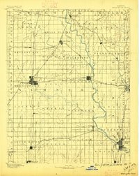
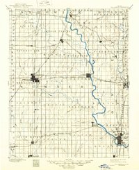
1890 Map of Wellington
USGS Topo · Published 1896About this map
The Arkansas River serves as the primary geographical spine of this region during a period of rapid railway expansion and township organization. The network of competing rail lines is dense, including the Atchison Topeka and Santa Fe Railroad and the Chicago Kansas and Nebraska Railroad, which intersect at the bustling hub of Wellington. To the east, Winfield and Arkansas City anchor the riverbanks, with the latter showing a complex of surveyed blocks just north of the territory line. Smaller, specialized settlements appear as vital local nodes, such as the mineral water destination at Geuda Springs and the nearby Salt City. The landscape is methodically divided into named townships like Seventy Six, Valverde, and Palestine, reflecting the settled agricultural grid of the late nineteenth century. In the far south, Hunnewell and Drury mark the edge of the survey near the border, where the St Louis and San Francisco Railroad cuts through the township of Walton.
Find a feature on this map
92 named features on this map. Tap any name to fly to it.
Don’t see what you’re looking for? This feature index may not catch every label — zoom into the map to look around manually.
Map Details
Editions of this 1890 Wellington Map
6 editions found
Other maps of this area

1888 · Eldorado
USGS Topo · 1:125,000

1889 · Burden
USGS Topo · 1:125,000

1889 · Cheney
USGS Topo · 1:125,000

1889 · Wichita
USGS Topo · 1:125,000

1889 · Caldwell
USGS Topo · 1:125,000

1890 · Wellington
USGS Topo · 1:125,000

1891 · Cheney
USGS Topo · 1:125,000

1893 · Caldwell
USGS Topo · 1:125,000

1894 · Wichita
USGS Topo · 1:125,000

1897 · Caldwell
USGS Topo · 1:125,000