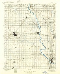
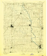
1890 Map of Wellington
USGS Topo · Published 1949About this map
Wellington and the surrounding townships of Sumner County are defined by an expansive grid of agricultural sections and a burgeoning rail network in the late 19th century. Surveyed in 1887, this map illustrates the pivotal role of transportation in Kansas settlement, with the Atchison Topeka and Santa Fe Railroad and the Chicago Kansas and Nebraska Railroad converging at major hubs. The Arkansas River meanders through the eastern portion of the sheet, providing a natural corridor for towns like Oxford and the mineral springs at Geuda Springs. Smaller, specialized settlements such as Seely, Cicero, and Rome appear as vital local centers for the farming townships of Seventy Six and Palestine. The density of named creeks, including Shoo Fly Creek and Bitter Creek, highlights the importance of water access for the region's early cattle and wheat economy.
Find a feature on this map
94 named features on this map. Tap any name to fly to it.
Don’t see what you’re looking for? This feature index may not catch every label — zoom into the map to look around manually.
Map Details
Editions of this 1890 Wellington Map
6 editions found
Other maps of this area

1888 · Eldorado
USGS Topo · 1:125,000

1889 · Burden
USGS Topo · 1:125,000

1889 · Cheney
USGS Topo · 1:125,000

1889 · Wichita
USGS Topo · 1:125,000

1889 · Caldwell
USGS Topo · 1:125,000

1890 · Wellington
USGS Topo · 1:125,000

1891 · Cheney
USGS Topo · 1:125,000

1893 · Caldwell
USGS Topo · 1:125,000

1894 · Wichita
USGS Topo · 1:125,000

1897 · Caldwell
USGS Topo · 1:125,000