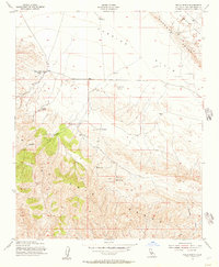
1954 Map of Wells Ranch
USGS Topo · Published 1957About this map
Carrizo Plain and the sharp rise of the Elkhorn Scarp dominate this mid-century look at the arid borderlands of San Luis Obispo and Kern counties. The landscape is defined by large-scale ranching operations and vital water sources in an otherwise dry environment, with the Kern County Land Co Ranch and Seaback Ranch situated at the foothills of the Caliente Range. The existence of The Old Adobe suggests earlier periods of habitation near the drainage of Abbott Canyon. Infrastructure is focused on survival and livestock, marked by numerous Grain Tanks and essential watering points like Semper Spr and Wells Spring. The detailed contouring reveals the geological intensity of the scarp and the deep incisions of Padrones Canyon as they descend toward the flats of Wells Ranch.
Find a feature on this map
18 named features on this map. Tap any name to fly to it.
Don’t see what you’re looking for? This feature index may not catch every label — zoom into the map to look around manually.
Map Details
Editions of this 1954 Wells Ranch Map
3 editions found
Other maps of this area

1902 · Santa Ynez
USGS Topo · 1:125,000

1905 · Santa Ynez
USGS Topo · 1:125,000

1912 · McKittrick
USGS Topo · 1:125,000

1941 · Caliente Mountain
USGS Topo · 1:62,500

1941 · McPherson Peak
USGS Topo · 1:62,500

1942 · Caliente Mtn
USGS Topo · 1:62,500

1942 · East of Cuyama Ranch
USGS Topo · 1:24,000

1943 · McPherson Peak
USGS Topo · 1:62,500

1943 · Caliente Mtn.
USGS Topo · 1:62,500

1943 · Cuyama Ranch
USGS Topo · 1:31,680