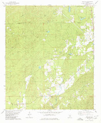
1979 Map of Weogufka
USGS Topo · Published 1980About this map
The community of Weogufka serves as the focal point of this 1970s landscape, situated where the ridge of Breastworks meets the winding path of Weogufka Creek. This era reveals a rural Alabama countryside characterized by small settlements and numerous religious landmarks, including Browns Chapel, Grimes Chapel, and the Holy Springs Ch. The intersection of Talladega Co Coosa Co is marked by an indefinite boundary line, while the terrain is etched by drainage systems like Peckerwood Creek and Shelton Creek.
Find a feature on this map
38 named features on this map. Tap any name to fly to it.
Don’t see what you’re looking for? This feature index may not catch every label — zoom into the map to look around manually.
Map Details
Editions of this 1979 Weogufka Map
2 editions found
Other maps of this area

1890 · Talladega
USGS Topo · 1:125,000

1892 · Talladega
USGS Topo · 1:125,000

1901 · Wetumpka
USGS Topo · 1:125,000

1903 · Wetumpka
USGS Topo · 1:125,000

1915 · Gantts Quarry
USGS Topo · 1:48,000

1917 · Gantts Quarry
USGS Topo · 1:62,500

1944 · Goodwater
USGS Topo · 1:62,500

1947 · Goodwater
USGS Topo · 1:62,500

1953 · Montgomery
USGS Topo · 1:250,000

1953 · Birmingham
USGS Topo · 1:250,000