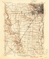
1925 Map of West Columbus
USGS Topo · Published 1946About this map
The Scioto River and Olentangy River define the eastern edge of this landscape, where the growing city of Columbus meets the agricultural townships of Franklin and Pickaway counties. This era reveals a dense network of early transportation, including the historic National Road and the Indiana Columbus and Eastern Electric railway. Notable institutional landmarks are prominent throughout the area, such as the Ohio State University campus, the State Hospital, and the Institute for Feebleminded.
Find a feature on this map
73 named features on this map. Tap any name to fly to it.
Don’t see what you’re looking for? This feature index may not catch every label — zoom into the map to look around manually.
Map Details
Editions of this 1925 West Columbus Map
This is the sole edition of this map. No revisions or reprints were ever made.
Other maps of this area

1901 · Dublin
USGS Topo · 1:62,500

1902 · Westerville
USGS Topo · 1:62,500

1903 · Dublin
USGS Topo · 1:62,500

1904 · Westerville
USGS Topo · 1:62,500
1906 · Mt Sterling
USGS Topo · 1:62,500
1907 · London
USGS Topo · 1:62,500
1911 · Era
USGS Topo · 1:62,500
1913 · Era
USGS Topo · 1:62,500
1914 · Circleville
USGS Topo · 1:62,500
1916 · Milford Center
USGS Topo · 1:62,500