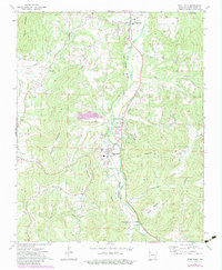
1973 Map of West Fork
USGS Topo · Published 1983About this map
The West Fork White River carves a central path through this Ozark landscape, serving as a corridor for both the Burlington Northern railroad and the primary settlements of Greenland and West Fork. This 1973 survey, later updated with early 1980s data, illustrates a rural Arkansas community where upland ridges like Miller Mountain and Bloyd Mountain overlook a network of valley farms and homesteads. Local history is deeply etched into the map through numerous country churches and burial grounds, including Union Star, Friendship Ch, and the Woolsey Cem near the small community of Woolsey. A large Quarry and a network of creeks such as Dye Creek and Hogeye Creek define the local industry and drainage. The map provides a detailed view of the transition from valley bottomlands to the steep relief of the surrounding mountains just before significant modern expansion altered the character of the region.
Find a feature on this map
39 named features on this map. Tap any name to fly to it.
Don’t see what you’re looking for? This feature index may not catch every label — zoom into the map to look around manually.
Map Details
Editions of this 1973 West Fork Map
3 editions found
Other maps of this area

1898 · Winslow
USGS Topo · 1:125,000

1899 · Fayetteville
USGS Topo · 1:125,000

1901 · Winslow
USGS Topo · 1:125,000

1901 · Fayetteville
USGS Topo · 1:125,000

1904 · Fayetteville
USGS Topo · 1:125,000

1946 · Fort Smith
USGS Topo · 1:250,000

1954 · Tulsa
USGS Topo · 1:250,000

1958 · Fayetteville
USGS Topo · 1:24,000

1958 · Elkins
USGS Topo · 1:24,000

1958 · Tulsa
USGS Topo · 1:250,000