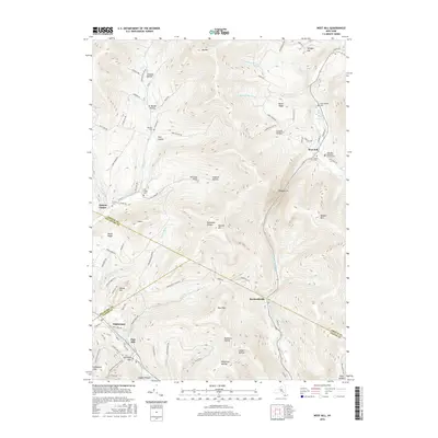
2016 Map of West Kill
USGS Topo · Published 2016About this map
West Kill and Halcott Center anchor this 2016 survey of the Catskill Mountains' high-relief landscape. The map details a complex network of hollows, including Johnson Hollow, Stanton Hollow, and Millbrook Hollow, which define the local settlement patterns. Genealogists can find several family-named burial sites such as Schermerhorn Cem and Deyoe Cem, alongside the West Kill Methodist Church Cem. The southern portion of the sheet transitions into the Ulster corridor near Pine Hill and Highmount, following the path of Bushnellsville Creek. High-elevation landmarks like Vly Mtn, Balsam Mtn, and the distinctive Deep Notch passage illustrate the challenging terrain that shaped early transportation routes. Notable local roads like Turk Hollow Rd and Kelly Hill Rd wind through the steep topography, connecting these small mountain communities.
Find a feature on this map
105 named features on this map. Tap any name to fly to it.
Don’t see what you’re looking for? This feature index may not catch every label — zoom into the map to look around manually.
Map Details
Editions of this 2016 West Kill Map
This is the sole edition of this map. No revisions or reprints were ever made.
Other maps of this area

1900 · Phoenicia
USGS Topo · 1:62,500

1901 · Margaretville
USGS Topo · 1:62,500

1901 · Gilboa
USGS Topo · 1:62,500

1903 · Gilboa
USGS Topo · 1:62,500

1903 · Phoenicia
USGS Topo · 1:62,500

1904 · Hobart
USGS Topo · 1:62,500

1904 · Margaretville
USGS Topo · 1:62,500
1945 · Seager
USGS Topo · 1:24,000

1945 · West Kill
USGS Topo · 1:24,000

1945 · Fleischmanns
USGS Topo · 1:24,000