2023 Map of West Kill
USGS Topo · Published 2023About this map
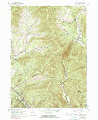
West Kill and Halcott Center are the primary settlements in this high-elevation region where the borders of Greene, Delaware, and Ulster counties converge. The landscape is defined by massive peaks including Halcott Mountain and Balsam Mountain, which funnel drainage into steep-walled gaps like Deep Notch. The map reveals a cluster of local history at the junction of West Kill and Roarback Brook, including the West Kill Methodist Church Cem and Westkill Community Cem. This 2023 survey provides a contemporary view of the isolated valleys such as Townsend Hollow and Turk Hollow, where residential development remains sparse due to the surrounding wilderness. To the south, the village of Pine Hill serves as a gateway near Cathedral Glen, while various family-named landmarks like St Meade Hollow and Bushnellsville reflect long-standing local lineage.
Find a feature on this map
97 named features on this map. Tap any name to fly to it.
Don’t see what you’re looking for? This feature index may not catch every label — zoom into the map to look around manually.
Map Details
Editions of this 2023 West Kill Map
This is the sole edition of this map. No revisions or reprints were ever made.
Historical Maps of Middletown Through Time
3 maps found