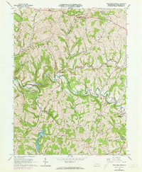
1964 Map of West Middletown
USGS Topo · Published 1973About this map
The hills of Washington County are deeply carved by Buffalo Creek and its many tributaries in this mid-1960s survey. The landscape is defined by a mix of agricultural ridge-tops and an emerging energy infrastructure, evidenced by numerous Oil Wells and Gas Wells clustered near Taylorstown and Donley. The creation of Dutch Fork Lake in the southwest corner provides a significant water feature, while substantial tracts are preserved as State Game Lands No 232.
Find a feature on this map
40 named features on this map. Tap any name to fly to it.
Don’t see what you’re looking for? This feature index may not catch every label — zoom into the map to look around manually.
Map Details
Editions of this 1964 West Middletown Map
3 editions found
Other maps of this area

1902 · Wheeling
USGS Topo · 1:62,500

1904 · Steubenville
USGS Topo · 1:62,500

1904 · Burgettstown
USGS Topo · 1:62,500

1906 · Burgettstown
USGS Topo · 1:62,500

1907 · Claysville
USGS Topo · 1:62,500

1935 · Wheeling
USGS Topo · 1:62,500

1935 · Steubenville
USGS Topo · 1:62,500

1942 · Wheeling
USGS Topo · 1:62,500

1942 · Steubenville
USGS Topo · 1:62,500

1951 · Canton
USGS Topo · 1:250,000
Featured Places
- Independence Township, PA
- West Middletown, PA
- Donley, Donegal Township
- Hopewell Township, PA
- Blaine Township, PA