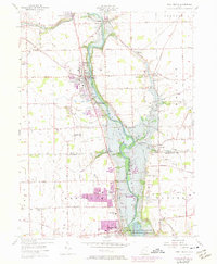
1955 Map of West Milton
USGS Topo · Published 1974About this map
The Stillwater River corridor defines this landscape, as the Stillwater Reservoir stretches south toward the Miami Conservancy District (Englewood Reserve). This mid-century survey, updated in the early 1970s, illustrates the expansion of West Milton and Union, with purple-tinted areas showing new development around the older village cores. The Penn Central rail line tracks across the northern half of the sheet, passing through the hamlets of Ludlow Falls and Kessler.
Find a feature on this map
82 named features on this map. Tap any name to fly to it.
Don’t see what you’re looking for? This feature index may not catch every label — zoom into the map to look around manually.
Map Details
Editions of this 1955 West Milton Map
5 editions found
Other maps of this area

1904 · Dayton
USGS Topo · 1:62,500

1905 · Brookville
USGS Topo · 1:62,500

1906 · Dayton
USGS Topo · 1:62,500

1911 · Covington
USGS Topo · 1:62,500

1914 · Troy
USGS Topo · 1:62,500

1944 · Covington
USGS Topo · 1:62,500

1944 · Troy
USGS Topo · 1:62,500

1953 · Cincinnati
USGS Topo · 1:250,000

1953 · Muncie
USGS Topo · 1:250,000

1955 · West Milton
USGS Topo · 1:24,000