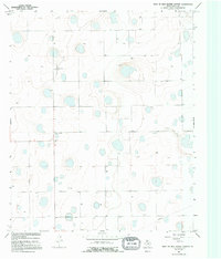
1966 Map of West of Dick Moore Canyon
USGS Topo · Published 1995About this map
The High Plains of Floyd County are captured here during the mid-1960s, showing a landscape defined by industrial water management and small agricultural hubs. The small settlement of Rushing sits near the western edge, anchored by Rushing Chapel and the nearby Rushing Chapel Cem. This area of the Llano Estacado is characterized by numerous depressions or playas, many marked simply as Well, indicating the critical role of groundwater for the region's ranching and farming operations. Outside of the primary settlement, the Irwin Landing Area stands out as a localized landmark. The presence of a long Pipeline cutting across the southern sections further reflects the infrastructure required to support energy or water transport across this distinctive Texas terrain.
Find a feature on this map
6 named features on this map. Tap any name to fly to it.
Don’t see what you’re looking for? This feature index may not catch every label — zoom into the map to look around manually.
Map Details
Editions of this 1966 West of Dick Moore Canyon Map
2 editions found
Other maps of this area

1954 · Lubbock
USGS Topo · 1:250,000

1954 · Plainview
USGS Topo · 1:250,000

1958 · Plainview
USGS Topo · 1:250,000

1965 · Lockney SE
USGS Topo · 1:24,000

1965 · Floydada
USGS Topo · 1:24,000

1965 · Boothe
USGS Topo · 1:24,000

1966 · South Plains
USGS Topo · 1:24,000

1966 · Lockney 4 SW
USGS Topo · 1:24,000

1967 · Quitaque Peaks
USGS Topo · 1:24,000

1967 · Dick Moore Canyon
USGS Topo · 1:24,000