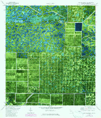
1971 Map of West Palm Beach 2 SE
USGS Topo · Published 1984About this map
The J W Corbett Wildlife Management Area dominates the northern reaches of this Florida landscape, showcasing the preservation of wetlands before the intense agricultural and residential expansion of later decades. This 1971 survey, updated with 1980 aerial photogrammetry, reveals a striking contrast between the organic patterns of the natural environment and the rigid, gridded geometry of managed land to the south and east. Distinctive human imprints are found in the remote Landing Strip and the South Florida Youth Conservation Camp Sewage Disposal site, indicating specialized land use within the conservation area. Water management is a central theme, with the presence of a Canal and Slough near the area identified as Hungryland, documenting the hydrological engineering essential to the development of Palm Beach County.
Find a feature on this map
6 named features on this map. Tap any name to fly to it.
Don’t see what you’re looking for? This feature index may not catch every label — zoom into the map to look around manually.
Map Details
Editions of this 1971 West Palm Beach 2 SE Map
3 editions found
Other maps of this area

1945 · Delta
USGS Topo · 1:24,000

1946 · Palm Beach Farms
USGS Topo · 1:24,000

1948 · Rood
USGS Topo · 1:24,000

1949 · Rood
USGS Topo · 1:24,000

1949 · Palm Beach Farms
USGS Topo · 1:24,000

1950 · Delta
USGS Topo · 1:24,000

1956 · West Palm Beach
USGS Topo · 1:250,000

1957 · West Palm Beach
USGS Topo · 1:250,000

1958 · West Palm Beach
USGS Topo · 1:250,000

1970 · West Palm Beach 2 SW
USGS Topo · 1:24,000