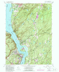
1957 Map of West Point
USGS Topo · Published 1988About this map
The U S Military Academy West Point and its surrounding riverine landscape define this mid-century survey of the Hudson Highlands. Centered on the strategic narrows of the Hudson River, the map documents the military institution's complex infrastructure, including Michie Stadium, the U S Silver Depository, and Lusk Reservoir. Across the water, the industrial and residential patterns of Cold Spring and Nelsonville sit tucked beneath the steep slopes of Bull Hill. The terrain is characterized by dramatic elevation changes and a high density of religious and educational institutions, such as St Basils Academy and St Josephs Novitiate. The presence of the Conrail rail line and the New York Albany Post Road highlights the area's role as a vital transportation corridor connecting the Hudson Valley's historic settlements.
Find a feature on this map
95 named features on this map. Tap any name to fly to it.
Don’t see what you’re looking for? This feature index may not catch every label — zoom into the map to look around manually.
Map Details
Editions of this 1957 West Point Map
4 editions found
Other maps of this area

1892 · West Point
USGS Topo · 1:62,500

1893 · Poughkeepsie
USGS Topo · 1:62,500

1894 · West Point
USGS Topo · 1:62,500

1894 · Poughkeepsie
USGS Topo · 1:62,500

1899 · West Point
USGS Topo · 1:62,500

1901 · West Point
USGS Topo · 1:62,500

1902 · Schunemunk
USGS Topo · 1:62,500

1903 · Poughkeepsie
USGS Topo · 1:62,500

1903 · Newburg
USGS Topo · 1:62,500

1930 · Schunemunk
USGS Topo · 1:48,000