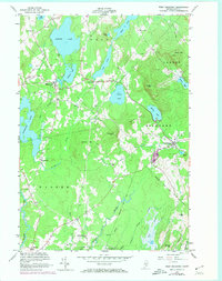
1955 Map of West Rockport
USGS Topo · Published 1974About this map
Alford Lake and the surrounding mid-coast highlands dominate this mid-century landscape in Knox County. The area is defined by a dense network of freshwater bodies including Hobbs Pond, Lermond Pond, and Mirror Lake, which supported early industrial activity like that found at Wattons Mill. Small rural settlements such as South Hope, East Union, and West Rockport anchor the crossroads, while family-named peaks like Gurney Hill, Ragged Mtn, and Dodge Mtn provide significant topographic relief. Local history is preserved in small enclaves like Mank and Kallock, and the presence of Goulds Hospital indicates the infrastructure of the era. The southern portion of the sheet is marked by the meandering paths of the St George River and the Oyster River, alongside the marshy expanse known as The Bog.
Find a feature on this map
50 named features on this map. Tap any name to fly to it.
Don’t see what you’re looking for? This feature index may not catch every label — zoom into the map to look around manually.
Map Details
Editions of this 1955 West Rockport Map
5 editions found

Other maps of this area

1904 · Rockland
USGS Topo · 1:62,500

1906 · Rockland
USGS Topo · 1:62,500

1913 · Waldoboro
USGS Topo · 1:48,000

1915 · Waldoboro
USGS Topo · 1:62,500

1915 · Belfast
USGS Topo · 1:62,500

1916 · Liberty
USGS Topo · 1:62,500

1917 · Belfast
USGS Topo · 1:62,500

1941 · Belfast
USGS Topo · 1:62,500

1941 · Rockland
USGS Topo · 1:62,500

1941 · Waldoboro
USGS Topo · 1:62,500