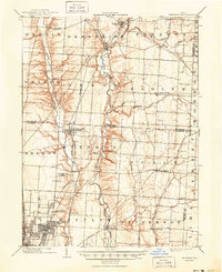
1904 Map of Westerville
USGS Topo · Published 1950About this map
Alum Creek and Big Walnut Creek flow south through this Central Ohio landscape, defining the development of small communities at the turn of the century. The town of Westerville sits as a primary hub along the Cleveland Akron and Columbus R. R., while an early Electric R. R. line cuts through Minerva Park toward Columbus. The map details a transition from the compact grid of Linden in the southwest to established rural centers like New Albany, Sunbury, and Galena. Smaller, localized landmarks like Central College, Parks Mills, and Havens Corners provide specific points of interest for those researching the early 1900s geography of Delaware and Franklin Counties. These waterways and rail corridors served as the primary transit routes before the era of modern highways, shaping the growth of townships like Blendon and Jefferson.
Find a feature on this map
51 named features on this map. Tap any name to fly to it.
Don’t see what you’re looking for? This feature index may not catch every label — zoom into the map to look around manually.
Map Details
Editions of this 1904 Westerville Map
2 editions found
Other maps of this area

1901 · Dublin
USGS Topo · 1:62,500

1902 · Westerville
USGS Topo · 1:62,500

1903 · Dublin
USGS Topo · 1:62,500

1904 · Westerville
USGS Topo · 1:62,500

1907 · Thurston
USGS Topo · 1:62,500

1908 · Granville
USGS Topo · 1:62,500

1909 · Thurston
USGS Topo · 1:62,500

1910 · Granville
USGS Topo · 1:62,500

1915 · Marengo
USGS Topo · 1:62,500

1915 · Fredericktown
USGS Topo · 1:62,500