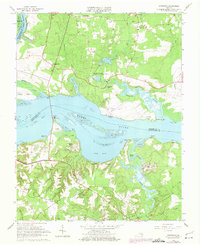
1965 Map of Westover
USGS Topo · Published 1975About this map
James River shorelines define this mid-1960s landscape, where the tidal flats and marshes of Tar Bay meet the historic plantation lands of Charles City and Prince George counties. The map documents a blend of colonial legacy and mid-century conservation, notably featuring the Presquille Nwr on Eppes Island and the Harrison Lake National Fish Hatchery. Along the river banks, established landmarks like Harrisons Landing and Westover sit across from the developing residential patterns at Beechwood Manor and the Jordan Point Country Club. Inland, the economy is marked by scattered agriculture, woodland, and local industry such as the Gravel Pits near Powell Creek. The presence of several historic houses of worship, including Merchant Hope Ch and Gillfield Ch, provides significant grounding for genealogists tracing family roots in this Tidewater region.
Find a feature on this map
57 named features on this map. Tap any name to fly to it.
Don’t see what you’re looking for? This feature index may not catch every label — zoom into the map to look around manually.
Map Details
Editions of this 1965 Westover Map
Other maps of this area

1894 · Bermuda Hundred
USGS Topo · 1:62,500

1894 · Petersburg
USGS Topo · 1:62,500

1918 · Charles City
USGS Topo · 1:62,500

1919 · Disputanta
USGS Topo · 1:62,500

1938 · Dutch Gap
USGS Topo · 1:24,000

1943 · Savedge
USGS Topo · 1:31,680

1943 · Dutch Gap
USGS Topo · 1:31,680

1943 · Hopewell
USGS Topo · 1:31,680

1943 · Disputanta
USGS Topo · 1:31,680

1943 · Richmond
USGS Topo · 1:250,000