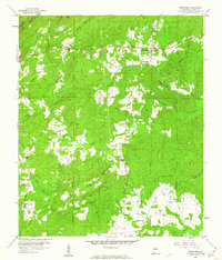
1959 Map of Westover
USGS Topo · Published 1960About this map
The Atlantic Coast Line railroad and the Florida Short Route highway intersect at the settlement of Westover, forming a transportation hub amidst the ridges of Shelby County. This late 1950s landscape is defined by its numerous small community centers, often centered around churches and cemeteries that likely served as local anchors for families and homesteads. High ground to the north is dominated by the parallel lines of Double Mtn and Straight Ridge, which channel the drainage of Little Mountain Creek and North Fork Yellowleaf Creek. For genealogists and local historians, the map preserves the exact locations of family-named landmarks like Hubbard Cem and Walton Cem, alongside specialized sites such as a Chert Pit and a Gaging Sta on the main branch of Yellowleaf Creek.
Find a feature on this map
37 named features on this map. Tap any name to fly to it.
Don’t see what you’re looking for? This feature index may not catch every label — zoom into the map to look around manually.
Map Details
Editions of this 1959 Westover Map
4 editions found
Other maps of this area

1890 · Bessemer
USGS Topo · 1:125,000

1890 · Talladega
USGS Topo · 1:125,000

1892 · Talladega
USGS Topo · 1:125,000

1892 · Bessemer
USGS Topo · 1:125,000

1906 · Vandiver
USGS Topo · 1:62,500

1908 · Vandiver
USGS Topo · 1:62,500

1909 · Columbiana
USGS Topo · 1:62,500

1911 · Columbiana
USGS Topo · 1:62,500

1915 · Gantts Quarry
USGS Topo · 1:48,000

1917 · Gantts Quarry
USGS Topo · 1:62,500