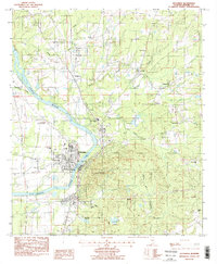
1987 Map of Wetumpka
USGS Topo · Published 1987About this map
The Coosa River anchors this 1980s landscape, winding past the historic core of Wetumpka and the northern settlement of Wallsboro. The era's community infrastructure is well-defined, showing the city's growth through institutional sites like the Julia Tutwiler Prison, a Grammar Sch, and the Vocational Center. Numerous rural congregations such as Mt Canaan Ch, Tunnell Chapel, and West End Ch dot the surrounding countryside, often situated near family burial grounds like Batchler Cem.
Find a feature on this map
31 named features on this map. Tap any name to fly to it.
Don’t see what you’re looking for? This feature index may not catch every label — zoom into the map to look around manually.
Map Details
Editions of this 1987 Wetumpka Map
2 editions found
Other maps of this area

1901 · Wetumpka
USGS Topo · 1:125,000

1901 · Wetumpka
USGS Topo · 1:62,500

1903 · Wetumpka
USGS Topo · 1:125,000

1927 · Montgomery
USGS Topo · 1:48,000

1930 · Montgomery
USGS Topo · 1:62,500

1953 · Montgomery
USGS Topo · 1:250,000

1956 · Montgomery
USGS Topo · 1:250,000

1957 · Montgomery
USGS Topo · 1:250,000

1958 · Montgomery
USGS Topo · 1:62,500

1958 · Montgomery North
USGS Topo · 1:24,000